Smartphones have dramatically improved the way people access information in everyday life. Printed timetables and paper maps have largely been replaced by digital tools that make navigation faster and easier.
However, standard digital maps do not always meet every need. Users often find that:

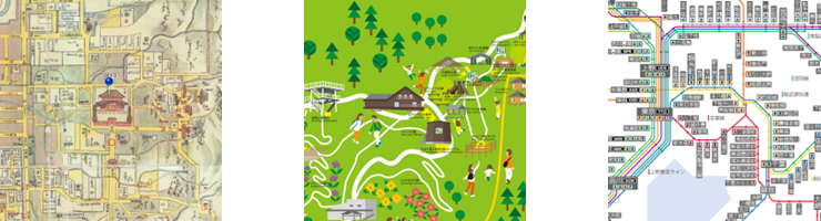
- conventional smartphone maps are visually functional but do not always convey the character of a place,
- illustrated town maps and tourism maps are enjoyable to use but make it difficult to identify one’s current location, and
- historical maps would be far more useful if they could be linked directly to real-world positioning data.
Maplat was developed to solve exactly these challenges.
What Maplat Enables
With Maplat, users can:
- overlay historical maps and illustrated maps onto accurate modern maps,
- display their current location on those maps using GPS*1,
- align non-precise spatial representations without losing positional consistency,
(Japanese Patent No. 6684776) - compare maps from different periods to understand urban change over time,
- use these functions through an interface designed to be intuitive and accessible.
For more information on the underlying technology and approach, please see Key Features of Maplat.
*1 What is GPS?
GPS, or Global Positioning System, is a technology used to determine location on Earth through signals received from satellites. It is widely used in smartphones, car navigation systems, and other location-aware devices.

A Platform for Place-Based Storytelling and Smart Cities
Cities become more compelling when the story of where they came from and the story of where they are going are meaningfully connected.
By enabling both historical interpretation—through education and tourism—and future-oriented urban applications—through smart-city initiatives—Maplat serves as a platform that connects memory, place, and innovation. We see it as a foundational geospatial information platform for the next generation of cities.